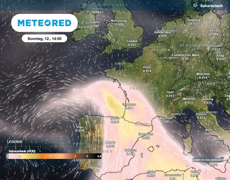
At Brenda, Weilmoringle, Kenebree, Goodooga, Goodwins and Angledool
Flood Warning
2022-05-27 14:30
2022-05-30 17:30
Kommentar
Moderate to Major Flood Warning for the Culgoa, Birrie, Bokhara and Narran Rivers
Details
MAJOR FLOODING OCCURRING AT ANGLEDOOLMAJOR FLOODING POSSIBLE AT BRENDA, WEILMORINGLE AND KENEBREE FROM NEXT WEEKMODERATE FLOODING POSSIBLE AT GOODOOGA FROM EARLY NEXT WEEKMODERATE FLOODING POSSIBLE AT GOODWINS FROM MID JUNEModerate to heavy local rainfall in mid May, combined with floodwaters from Queensland, have caused renewed and prolonged flooding along the Culgoa, Birrie, Bokhara and Narran Rivers.Along the Culgoa River, moderate flooding is occurring at Brenda and minor flooding is occurring at Weilmoringle, where renewed rises to major flood levels are possible from next week. These floodwaters may also cause major flooding downstream at Kenebree from mid June, where moderate flooding is currently occurring.At Dirranbandi (Qld) river levels peaked on 26 May, which is likely to contribute to renewed rises to the moderate flood level at Goodooga from early June.Along the Bokhara River, an earlier flood peak has passed Goodwins, where river levels peaked slightly below the moderate flood level (2.60 metres). Renewed rises to the moderate flood level are possible from mid June.Along the Narran River, major flooding continues at Angledool.A major flood warning is current for the Condamine and Balonne Rivers in Queensland.
At Mungindi, Mogil Mogil, Collarenebri, Walgett, Bourke, Louth, Tilpa, Menindee Town, Pooncarie and Burtundy
Flood Warning
2022-05-27 13:39
2022-05-30 13:39
Kommentar
Minor to Moderate Flood Warning for the Barwon and Darling Rivers
Details
RENEWED MODERATE FLOODING LIKELY AT MUNGINDI SUNDAYMINOR FLOODING OCCURRING AT MOGIL MOGIL, LIKELY AT BOURKE AND POSSIBLE AT COLLARENEBRI, WALGETT, LOUTH AND TILPAMINOR FLOODING EXPECTED AT MENINDEE TOWN AND DOWNSTREAMRenewed minor flooding is occurring along the Barwon River at Mungindi, where moderate flooding likely over the coming weekend, driven by floodwaters from the Weir and Macintyre Rivers (Qld).Floodwaters from the Barwon River, Moonie River (Qld) and Gil Gil Creek are arriving at Mogil Mogil where river levels are peaking with minor flooding.Floodwaters of the main flood peak currently at Mogil Mogil are expected to move through Collarenebri around the end of May causing minor flooding. Minor flooding is possible at Walgett early June.Floodwaters from the Culgoa River combined with floodwaters from the Barwon River have the potential to cause minor flooding along the Darling River at Bourke from early next week.Minor flooding is possible along the Darling River at Louth and Tilpa. Peak predictions will be provided once the upstream peaks are observed.River levels at Menindee Town are expected to exceed the minor flood level (8.50 metres) from Friday night as WaterNSW increases the releases from the Menindee Lake. WaterNSW are responding to changed forecasts in upstream inflows that now exceed the capacity for storage at Menindee Lakes. River levels at Menindee Town may reach 9.00 metres early June when the releases are stabilised. The release plan follows consultation with the SES and local communities.Minor flooding is likely at Pooncarie and Burtundy from mid June.
At Willara Crossing and Wanaaring
Flood Warning
2022-05-27 11:50
2022-05-30 11:50
Kommentar
Minor Flood Warning for the Paroo River (NSW)
Details
MINOR FLOODING CONTINUES AT WILLARA CROSSINGMINOR FLOODING LIKELY OCCURRING AT WANAARINGThe Paroo River at Willara Crossing peaked on Sunday evening, with minor flooding. The flood peak is now at Wanaaring where a minor flood peak is likely occurring. Data for Wanaaring was unavailable at the issue time of this warning.
Northern Rivers, Mid North Coast, Hunter, Metropolitan, Illawarra, South Coast, Central Tablelands, Southern Tablelands, Central West Slopes and Plains, South West Slopes, Riverina, Lower Western, Australian Capital Territory, Northern Tablelands and parts of North West Slopes and Plains, Upper Western and Snowy Mountains Forecast Districts.
Severe Weather Warning
2022-05-29 16:51
2022-05-29 23:00
Kommentar
Damaging winds developing overnight and extending east during Monday.
Details
DAMAGING WINDS averaging 70 km/h with peak gusts in excess of 90 km/h are likely over the far west of New South Wales from early Monday morning, reaching the Great Dividing Range by Monday afternoon and the east coast Monday evening.Saturated soils bring an increased risk of gusty winds toppling trees and powerlines.Locations which may be affected include Lismore, Grafton, Coffs Harbour, Port Macquarie, Taree, Newcastle, Gosford, Sydney, Wollongong, Nowra, Batemans Bay, Armidale, Orange, Canberra, Goulburn, Tamworth, Dubbo, Wagga Wagga, Albury, Deniliquin, Cobar and Broken Hill.
At Fords Bridge
Flood Warning
2022-05-27 10:46
2022-05-30 10:46
Kommentar
Minor Flood Warning for the Warrego River (NSW)
Details
MINOR FLOODING POSSIBLE AT FORDS BRIDGE 2ND WEEK OF JUNEThe flood peak along the Warrego River has passed Rocky in Queensland and is now approaching Barringun where river levels are expected to remain below minor. The flood peak is expected to pass through Enngonia late next week 1 June - 3 June where river levels are also expected to remain below the minor flood level.Minor flooding possible at Fords Bridge as the flood peak approaches in the second week of June (6 - 10 June).
At Booligal
Flood Warning
2022-05-27 10:34
2022-05-30 10:34
Kommentar
Flood Warning for the Lachlan River
Details
NEAR MINOR FLOODING OCCURRING AT BOOLIGALRecent rainfall across the lower Lachlan River catchment, combined with earlier flood peaks is causing near minor flooding at Booligal Weir. Further slight rises are possible over the coming weekend.